Jaxon Ingold
Portfolio
-
Beneath the Surface: A Transdisciplinary Approach to Geospatially Characterising and Predicting Lava Caves in Tāmaki Makaurau Auckland, Aotearoa New Zealand
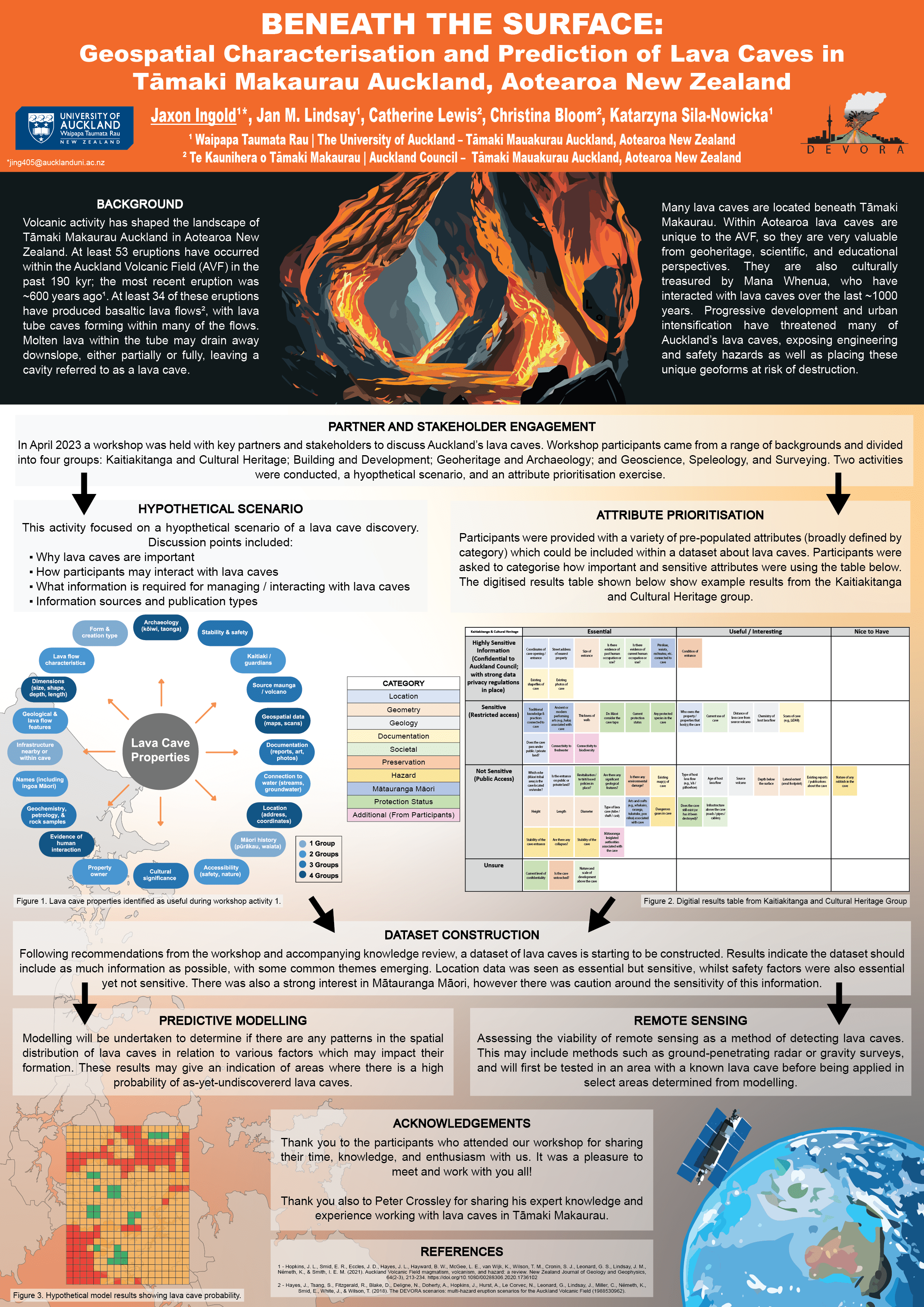
This poster briefly summarises my Bachelor of Science (Honours) and masters research projects. I am investigating lava caves in Tāmaki Makaurau Auckland. Many lava caves are located under the landscape, some known and protected as geoheritage features and others discovered frequently through earthworks and drilling during developments. Within Aotearoa lava caves are unique to the AVF, so they are valuable from geoheritage, scientific, and educational perspectives. They are also culturally treasured by indigenous Māori, who have interacted with lava caves in a variety of ways while living in Tāmaki Makaurau over the last ~1000 years. Progressive development and intensification have threatened many of Auckland’s lava caves, exposing engineering and safety hazards for construction as well as placing these unique geoforms at risk of destruction.
This study applies a transdisciplinary approach towards characterising lava caves in Tāmaki Makaurau and building a dataset for multi-purpose use in an effort to better understand and preserve these features. Our current findings, following a review of existing knowledge and engagement with key partners and stakeholders (representing a range of cultural, engineering, heritage, and geological perspectives), indicate a wide range of information that needs to be incorporated into the AVF lava cave dataset. Once consolidated, this information will support a range of activities, including management, preservation, hazard evaluations, research, and possible prediction of further as-yet-undiscovered lava caves.
Thank you to everyone who has supported this work so far! The project is still underway, so keep an eye out for results in the near future!
-
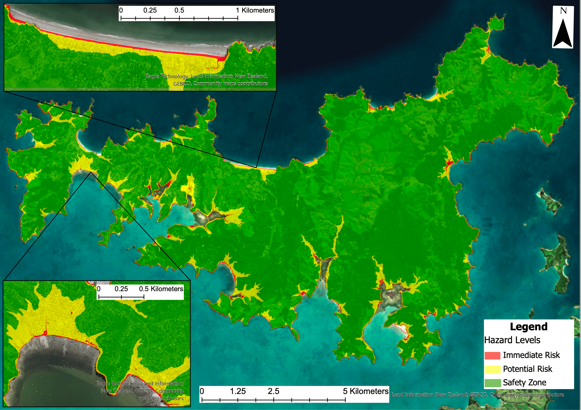
A GIS-based tsunami evacuation assessment of Waiheke Island, New Zealand, using a network analysis approach.
In 2022 for my final year capstone research project I completed a GIS based tsunami evacuation evaluation for Waiheke Island, in Tāmaki Makaurau Auckland, supervised by Dr Katarzyna Sila-Nowicka. I first performed a primary hazard assessment to assess the extent to which a locally sourced tsunami may impact the island. A network analysis approach was then utilised to evaluate how evacuation procedures occur throughout vulnerable regions, including a closest facility analysis (determining nearest evacuation points) and service area analysis (assessing potential evacuation timeframes).
-
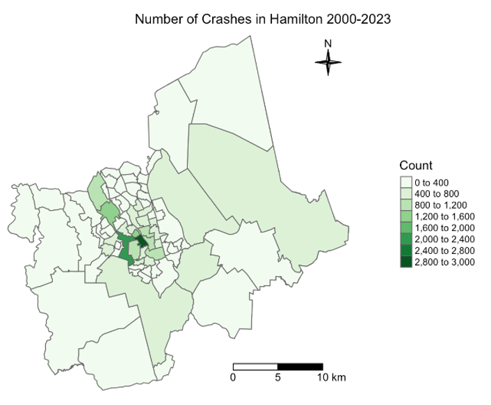
Towards Improving Road Safety in Hamilton City: Analysing Factors Impacting Vehicle Crashes using Global Linear Regression and Geographically Weighted Regression
This study assessed the influences of a variety of environmental, infrastructure, and traffic related variables in relation to the number of crashes occurring from 2000-2023 across Hamilton City. 13 Independent variables were identified and evaluated with regards to collinearity and model optimization, with 9 variables selected for regression analysis. Regression analysis in the form of linear regression and geographically weighted regression were completed, with the local scale GWR performing at a higher model quality. Results indicated that some spatial relationships exist throughout Hamilton, particularly with regard to lighting variables that impact visibility. Parameter estimates, however, were relatively low across both models and there were few statistically significant variables at a local scale. These findings suggest that other factors may influence the number of crashes, such as driver behaviour or vehicle safety, which continues to be the focus of many studies within this domain. Data analysis and visualisations in this study were completed in R.
-
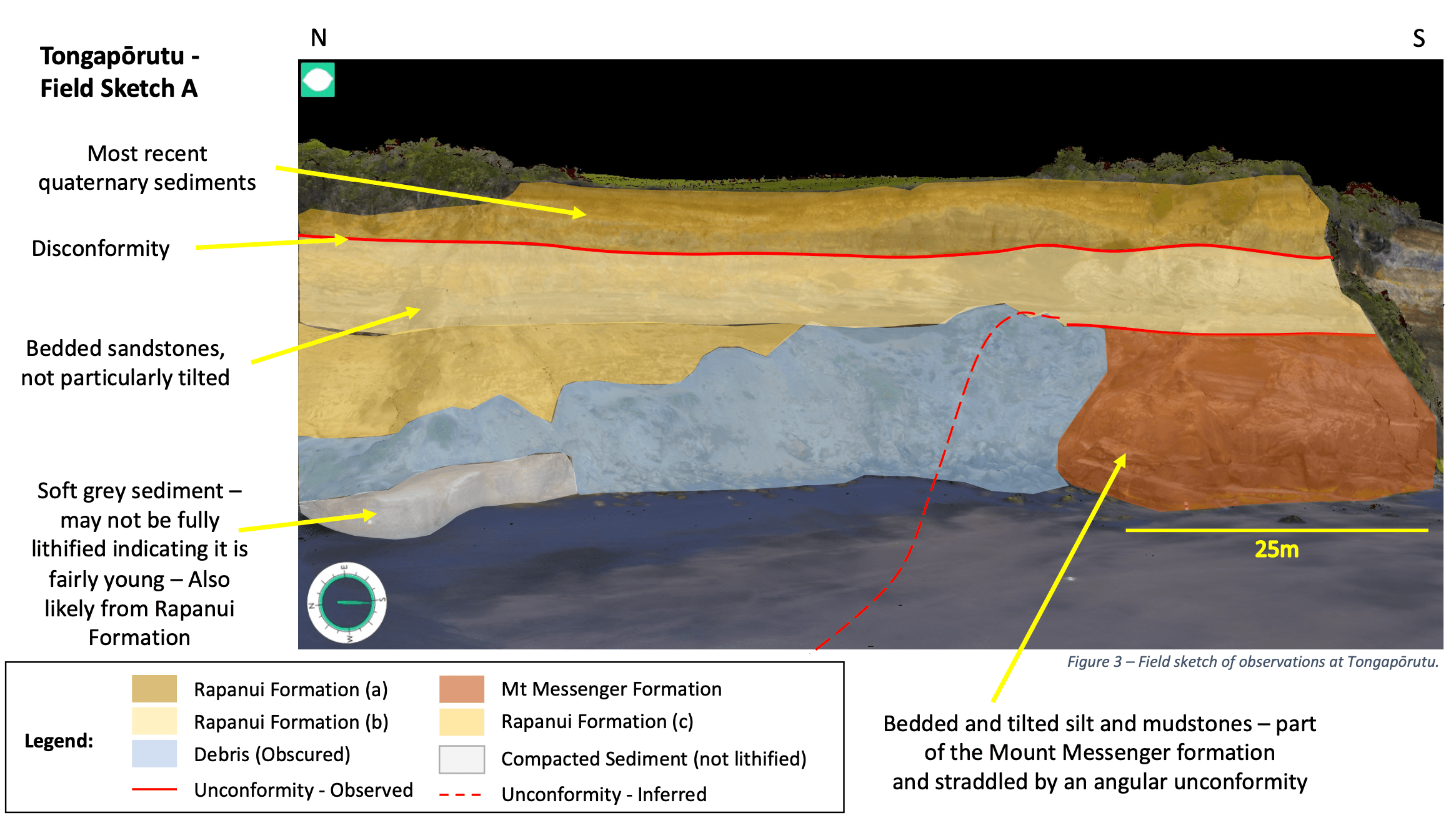
Geological Field Study - Taranaki Region
During my final core Earth Science course we finally (no thanks to the global pandemic) got a window of opportunity to go on a residential field trip to Ngāmotu New Plymouth to study the geology of the Taranaki Region. We travelled to various sites to complete assessments of various lithological features that are present in the area, including coastal cliffs (as well as sea stacks and caves, a river cutting and Mt Taranaki. We were challenged with determining the geologic setting of the area based on the deposits that we observed, which included sedimentary layers, debris flows (avalanches and lahars), and volcanic products. Following the field excursion we summarized our findings with annotated diagrams and maps, such as the one displayed here from the Mt Taranaki sites.
-
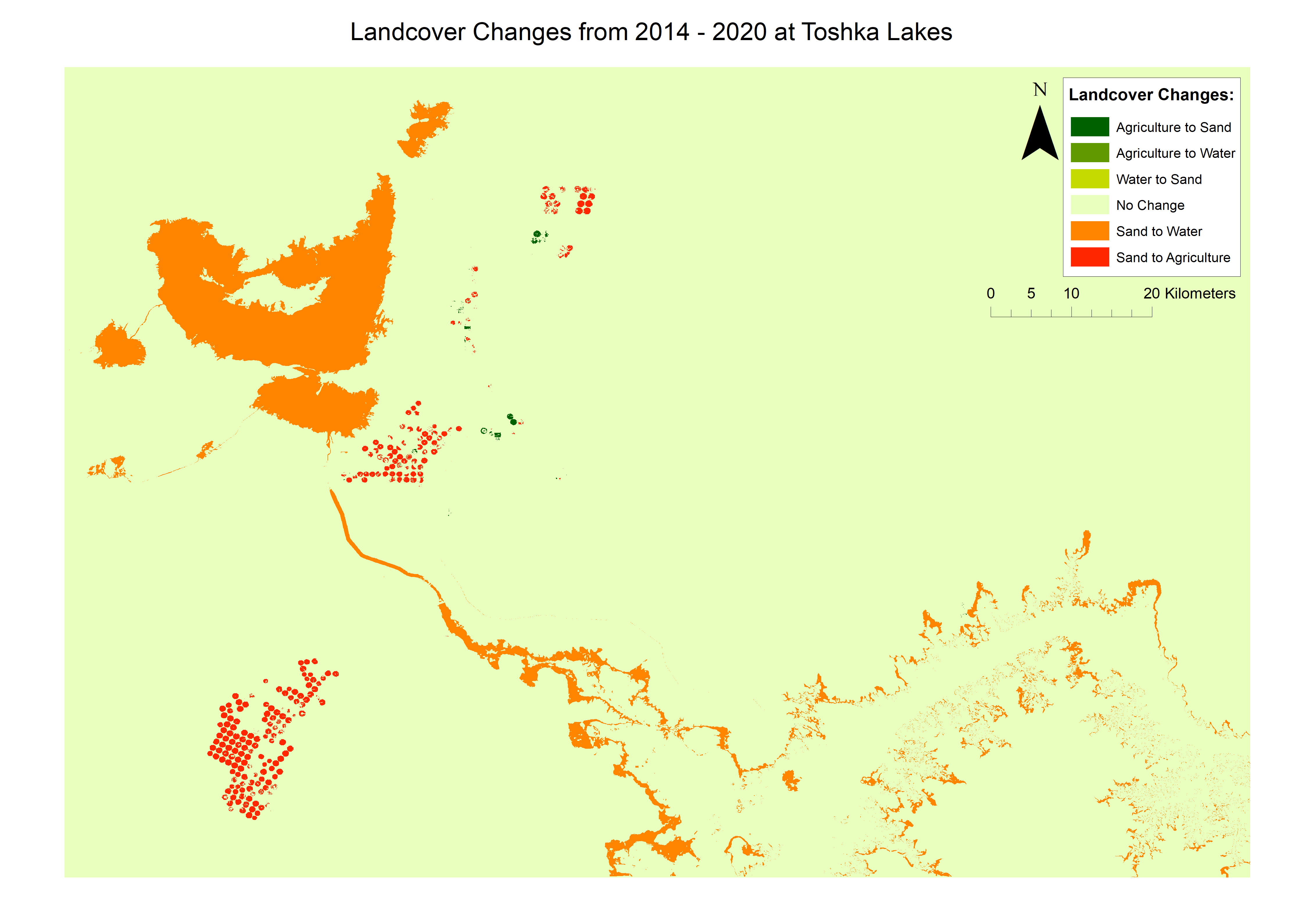
Land Cover Change Assessment - Toshka Lakes, Egypt
In this remote sensing project I completed a land cover change assessment for the area of Toshka Lakes, in Egypt. This was completed using a supervised classification method on Google Earth Engine, with results showing significant changes in land cover and land use. There was initially a period of continued reduction of the lake area as agricultural land expanded. This lake area reduction was clearly recognised in the region, and construction of a waterway from the Nile River significantly boosted the lake area in 2020.